WHO KNEW?
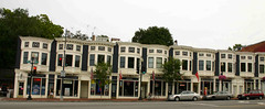
When posting images to the internet, as a documentary photography, it is imperative that I include as much accurate information, as possible, pertaining to each image that I post. And, therefore, I spend a great deal of time researching. Of course, the internet makes researching much easier. But, even then, one must be careful because the infomration posted to the internet may not necessarily be accurate.In the process of uploading images that I took of Key Bridge and in Georgetown on Labor Day Monday, 4 September 2006, I'd try my hand at geotagging, for the first time. Which took from yesterday afternoon until early this morning for me to figure out how to map my images. The problem resolved when I, finally, would download an updated verson of the Macro Flasher.
After dropping and dragging my Francis Scott Key Bridge photo set to the proper location on the yahoo/google map, I'd learn that the area surrounding Key Bridge is knwon as Tohoga. And that the intersection of M Street and Key Bridge known as Harlem is listed as a Historic Popular Place in the District of Columbia.
So, now I will embark on a documentary project to learn more about Tohoga and Harlem in the Georgetown area of WDC which Peter Square is located in the former. And the Foundary Branch Valley Park and John Carroll Statue, in the latter.
Who knew ...?


No comments:
Post a Comment