Tuesday, December 26, 2006

Chinatown's Friendship Archway designed by architect Alfred H. Liu

A traditional Chinese gate designed by local architect Alfred H. Liu, the Friendship Archway, was dedicated to Chinatown in Washington DC in 1986 . The colorful, $1 million work of public art includes 7 roofs up to 60 feet high, 7000 tiles, and 272 painted dragons in the style of the Ming and Qing Dynasties. Erected to celebrate friendship with Washington's sister city of Beijing, it was hoped the arch would reinforce the neighborhood's Chinese character. According to the plaque next to the arch, it is the largest such archway in the world. Read more at Wikipedia.

Click photo to view Friendship Archway ongoing photo project.

Friday, December 22, 2006

American Society of Landscape Architects

I would began my ongoing now documentary project, focusing on Chinatown WDC on New Years Eve, 31 December 2004, when during the course of my 2004/05 Holiday Season street photography I'd observe a newly constructed Gallery Place at the corner of 7th and H Streets, in NW WDC. Since that time, I have returned on many occasions to capture the always changing architecture and street scape of the area.

In recent months, I have observed significant changes in the 600 block of Eye Street, NW. One such change is a cluster of new buildings on the south side of the 600 block of Eye Street. One of which houses the American Society of Landscape Architects.

Founded in 1899, the American Society of Landscape Architects is the national professional association representing landscape architects. Beginning with 11 original members, ASLA has grown to more than 16,200 members and 48 chapters, representing all 50 states, US territories, and 42 countries around the world. ASLA promotes the landscape architecture profession and advances the practice through advocacy, education, communication, and fellowship.

The ASLA is located at 636 Eye Street in NW. Telephone 202-898-2444.

Another important observation that I've taken note of in the past year or so is that many of the newly constructed buildings and complexes in downtown WDC are embracing the green roof concept. Which, when reading the words etched unto ASLA's window I'd learn that landscape architects are designing and developmenting many green roof projects not only in WDC and across the nation but throughout the global community, as well.

Click the above photo to access my now ongoing ASLA documentary proejct.

Wednesday, December 13, 2006

Men At Work / 505 Ninth Street, NW

I began my documentation of the construction of 505 Ninth Street in September 2005. Since then I have learned that 505 Ninth Street is being developed as a joint venture by Boston Properties and KEG 1 Associates.

Designed by Hartman-Cox Architects this class A office building will feature superb views from its top floors, three levels of parking, two roof top decks, fitness center and concierge service. Construction commenced during the summer of 2005 with initial occupancy planned for the fall of 2007.

Included in my ongoing documentary project, Men At Work, this photo was taken on 12 December 2006.

Tuesday, December 12, 2006

Constitution Gardens, Washington DC

Bounded on the north by Constituion Avenue and on the south by Independence Avenue and situated just west of 17th Street, Constitution Gardens is a living legacy to the founding of the republic as well as an oasis in the midst of a city landscape. The 50 acres of the park were originally beneath the Potomac River! A U.S. Army Corps of Engineers dredging project at the turn of century created the land that became Potomac Park.

Monday, December 11, 2006

River Park in SW WDC

Composed of several clusters of townhouses and two high-rise buildings in a park-like setting, River Park structures feature a unique modernistic design created by the award-winning architect, Charles M. Goodman. Its 1200-plus residents form a dynamic community that makes River Park a great place to live. River Park is a main feature on the District of Columbia's Southwest Heritage Trail.

Tuesday, November 14, 2006

Lafayette (Peace) Park

Located directly across from and north of The White House, Lafayette Park also known as Peace Park is part of the Lafayette Square Historic District which is an area of Washington DC that I plan to explore and focus more on in upcoming months. Though I have visited Lafayette Park since the fall of 1972 when after barhopping at the gay bars on 9th Street that friends Tom Wiley, Tom Ocfemia, Allen Aud and I would 'cruise' the park before returning back to Wiley's apartment in Riverdale MD and, in recent years, have photographed many demonstrations in what is sometimes referred to as Peace Park this image, taken on Veterans Day, 11 November 2006, represents the launching of my Lafayette Square Historic District Project which includes the H, 15th and 17th Streets surrounding area

Friday, November 10, 2006

Survey Lodge Ranger Station @ GW Monument Grounds

Some weeks back I would begin my Mission 66 Project which, at the time, is a term that I had found when searching the internet but now that I have a little more information I realize may be an inaccurate acronym. And, as a result but, in the future, I may refer to the series as the National Park Service Architectural and Infrastructure Project.

En route to the Vietnam Veterans Memorial for the first installment of my Veterans Day 2006 Weekend Project I'd stop in at the National Park Service marble building located on Independence Avenue between 15th and 17th Streets, in SW, for the purpose of inquiring of the history of the structure as well as to inform the National Park Service of my now ongoing documentary project that will focus on the architecture and infrastucture not only on the National Mall but throughout the city and perhaps around the nation.

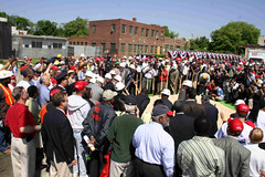
In these times of Homeland Security I must be extremely careful since, as a black male, it has always been my experience that racism plays a very important part in how folks react to me. And, thusly, to my photography. Which in my Friday, 10 November 2006 photoessay "I Saw A White Man Taking Pictures" I shed light on a situation that occured when I was photographing at the Vietnam Veterans Memorial. Which is the exact same reaction that I have encounted each time that I have visited or photographed at The Wall, since its November 1982 opening.

And since I put a deal of effort into my photography I have always returned home from documenting Rolling Thunder or Veterans Day at The Wall ... "mad as hell!".

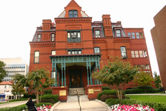
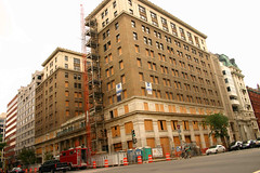
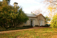
Though I have passed by this building many times and have been fascinated by it in similar ways that, for many years, I've marvelled at what I would learn a few minutes later to be the Monument Lodge this would be the first time that I would actually enter the building which, according the sign out front is the Survey Lodge Ranger Station.

The Survey Lodge Ranger Station is actually where the National Park Service conducts and coordinates its volunteer services for sites located within the National Mall & Memorial Parks area. Upon entering the lobby and while the volunteer person behind the receptionist desk was in the process of assisting a man with a child in a baby stroller I'd take the opportunity to look around. The interior architecture is of an area that I find most interesting. And that I hopoe to learn more about and, of course, photograph.

Upon the departure of the man and child I'd approach the receptionist, informing him that in recent months I had embarked on an ongoing documentary photographic project that focused on the architecture and infrastructure of the National Parks Services with a particular interest on buildings such as the Survey Lodge. I would then ask if he knew the history or knew where I could find information pertaining to the history of such buildings as the Survey Lodge or the other building just across the way that for many years served as a concessions stand and public rest rooms.

Park Ranger Harry Gedney would then inform me that, for many years, he had researched, spoken on and written about the history of the National Capital Parks which includes the National Mall and surrounding Memorial Parks. The building on 15th Street, which I referred to as the concessions stand, he would explain is known as the Monument Lodge. While Mr. Gedney is not too informed of Monument Lodge's history he did say that the Survey Lodge which was built after the completion of the George Washington Monument had, actually, been constructed from unusued marble, left over from the construction of the GW Monument.

And when originally built, the Survey Lodge, served as the boiler and steam room for the operation of the elevators at the GW Monument.

After years of research, and under the auspices of the National Park Service, in 1996 Mr. Gedney would publish Synopsis of the Policy History of the National Capital Region. And as result Mr. Gedney was able to to refer me to several resources listed in his bibliography and references.

And just before rushing off to the Vietnam Veterans Memorial, Mr. Gedney, presented me with a copy of GEORGE WASHINGTON: Man and Monument by Frank Freidel and Lonnelle Aikman. Which I am most grateful for and will certainly refer to.

I left the Survey Lodge feeling uplifted and extremely happy that I had encountered Park Ranger Harry Gedney. I say this because when leaving my apartment for the purpose of visiting the Vietnam Veterans Memorial I'd reflect on my experiences, at The Wall, over the years. And, the fact, that would again leve The Wall, mad as hell!

Many have asked, 'If you have those experiences then why do you keep going back?".

On Friday evening, 10 November 2006, I would, again, leave The Wall ... mad as hell!

And, yet, I am very thankful to Park Ranger Harry Gedney who suggested that if I wanted to return to the Survey Lodge, after visiting The Wall that he may ould have more references to refer me to. While my concern was that, in the evenings, once the sun goes down, the chill in the air affects my bones what I did not express to Mr. Gedney was that, if history repeated itself, "... and as a result of the racism that I would experience at The Wall I would be in no mood, condition nor dispostion to revisit the Survey Lodge, later that evening."

On my walk home across the National Mall I would if Harry Gedney would understand that "in sharpt to my white counter part, as a 53 year old black man, I have less freedoms now than I had 35 years ago which was when my closet white friends and I would visit and tour the National Mall.
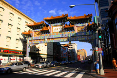
Thursday, November 09, 2006

Art on Call Project

Police and fire call boxes were installed throughout the capital starting in the 1860s. Although they became obsolete with the introduction of the 911 emergency call system in the 1970s, they remained on the streets.

Art on Call is a city-wide effort led by Cultural Tourism DC to restore Washington DC's abandoned police and fire call boxes as neighborhood artistic icons.

More than 20 neighborhood organizations are working on 301 call boxes as part of Art on Call. They have formed coalitions with residents and artists to propose, and then carry out, their ideas for refurbishing their neighborhood's call boxes.

Cultural Tourism DC and its partners have established a $250 matching grant for each proposal it approves. As of September 2005 $33,000 has been disbursed to fund 132 boxes. As of September 2005, 38 completed boxes were on view in Mount Pleasant, Capitol Hill, Dupont Circle, and Sheridan/Kalorama.

Art on Call is a project of Cultural Tourism DC in partnership with the DC Commission on the Arts and Humanities, the District Department of Transportation, and the Office of the Deputy Mayor for Planning and Economic Development.

For more information contact J. Brendan Meyer at BMeyer@CulturalTourismDC.org or 202-661-7581. Or visit Art on Call at Yahoo Groups.

The above photo was taken on 1 November 2006 at the corner First and N Streets, in SE, Washington DC which is directly across the street from the Washington Nationals (new) Stadium.

And in an attempt to preserve history, this particular call box which I have photograhed for several years, is a perfect canidate for the Art on Call Project. Three others of interest can be found at Half and M Streets, SW, and in the 1200 block of Delaware Avenue between M and N Streets, SW.

Wednesday, November 08, 2006

Demolition begins at Southwest Waterfront Mall

For several years, a banner proclaiming a new "Waterfront" development has hung over the Waterside Mall, at 401 M St., SW. Residents watched as mall stores closed in anticipation of the start of construction, leaving only a Safeway, CVS and a Bank ofAmerica branch. While internal demolition is finally underway, it is still unclear what will occupy this valuable piece of land once the development is completed.

Monday, November 06, 2006

Washington Nationals Ballpark, 6 months later


The first photo was taken on Wednesday afternoon, 1 November 2006 from the southeast pedestrian lane of the South Capitol Street Bridge between N and Streets in SE while the second was taken 6 months before on Thursday morning, 4 May 2006, at the corner of Half and O Streets, in SE, during the Washington Nationals Ballpark groundbreaking ceremony.

Tuesday, October 24, 2006

The Old With The New @ New U Street

Cognitive that in order to move forward or simply to gain a better understanding of the present one most know something about the past, in the process of my ongoing Cityscape, Architectural & Industrial Photography I've always made it a point to capture, document and record The Old With The New. It is with that understanding and hindsight that Out With Old & In With The New - Near Southeast DC Development represents the first installment of my Fall 2006 exhibition series.

The above photo of the Visio Condos was taken on Monday evening, 25 September 2006. I began my documentation of the Shaw area of Washington DC on 21 June 2005. Since then there have been so many changes in the area, it is my hope that I will return in the next few weeks to capture more of the old with the new.

Monday, October 16, 2006

Capitol Quarter emerges from the former Capper/Carrollsburg Projects

I began my Capper/Carrollsburg documentary project on Thanksgiving Monday, 29 November 2004 when during a photo assignment that I'd meet with Anu Yadav pertaining to a subsequent article in the 30 December 2004 issue of the Washington Spark by Judy Lem entitled Resisting a Local Diaspora: The Fight for Housing and for History in Arthur Capper and Carrollsburg.

Anu Yadav had written, produced and performed in a one woman play Capers at www.CapersThePlay.com which and not unlike my documentary project "This is for Black Men Who've Contemplated Suicide When That Rainbow ... Was Just Too Much!" was developed in a similar style as have been the plays developed and produced by Anna Deveare Smith.

A few days after my Yadav collaboration when I would return to the Arthur Capper to deliver photos to some of the subjects that I had captured just a few days before ... I was a bit taken back ... when I'd find them in the midst of moving. And had I arrived a half hour later I would have missed them, in accordance with the Capper Carrollsburg tenant relocation program.

And though I would not return to the Capper/Carrollsburg Community until June 2005 seldom have I passed through or have thought of the Arthur Capper Projects without reflecting on that Thursday or Friday evening, after Thanksgiving, when I found Brenda, Mechelle and Kia in the midst of moving. Or the many times, over the years before, that white friends would ask me if I could fetch drugs for them from 'The Projects'.

On Saturday, 14 October 2006, the Arthur Capper Projects would emerge from the gound as Capitol Quarter.

Sunday, October 08, 2006

Connecticut Avenue Dupont Circle Underpass Revitalization

Since the first week of May 2006 revitalization of the Connecticut Avenue Dupont Circle Underpass has been underway. Construction on the roadway and tunnel occurs Monday through Friday from 7 a.m. until 10 p.m and sometimes on Saturday. Revitalization of Connecticut Avenue between N and R streets, in Northwest, including upgrades in electrical and sewer lines is scheduled for completion in February 2007, weather permitting.

Wednesday, October 04, 2006

Q14, One Year Ago Today

It was one year ago today on 4 October 2005 that I began documenting the construction process of the then future condominiums at the northwest corner of Q and 14th Streets in the Logan Circle area of WDC. Which some months later I'd come to know as the Q14. One year later on Wednesday morning, 4 October 2006, and in the process of curating a Logan Circle Under Reconstruction Photographic Exhibition I'd return to The Q14 and capture the architectural development as opposed to Men At Work. Since then I've taken more than a passing interest in the architectural style of The Q14 Residences as well as other projects of Fred Bahrami and as a result will now embark on an ongoing pictorial project that will focus on the Fred Bahrami Collection.

Wednesday, September 27, 2006

The Blaine Mansion & The Massachusetts Avenue Historic District

Though 22 September represented the start of fall it was just hours after Richard's departure on Tuesday that, in connection with my ongoing project, In the Fall of the Year 2006, I would visit the Dupont Circle area to collect more images for my ongoing Historic Dupont Circle Main Streets and Dupont Circle Historic District projects.

Located just west of Dupont Circle the bold, monochromatic brick and terracotta building at 2000 Massachusetts Avenue is the Blaine Mansion built in 1881 for James G. Blaine, a Republican from Maine and three-time loser in his try for the White House. In 1901 George Westinghouse, of the electric company fame, bought this house and lived here until his death in 1914. This is the last standing Dupont Circle mansion of those homes that surrounded the circle in the earliest period of the area's development. Its newly renovated interior provides a historic setting for several firms.

As Chester A. Arthur settled into the White House in 1882, roofers a few blocks away were driving hand made nails to secure a new slate roof on a Dupont Circle mansion. Although the Arthur presidency hasn't weathered well (who even remembers President Arthur?), the roof on the Blaine Mansion lasted 115 years.

A new roof that was installed, in 2001, by Moisture Infiltration Consultants. Inc should last through an equally impressive number of presidencies. With 12,000 slate shingles weighing more than 27 tons, the roof is not only beautiful but extremely durable.

When searching the internet pertaining to the Blaine Mansion I'd learn that it is amongst the Massachusetts Avenue Historic District which includes buildings fronting on Massachusetts Avenue from 17th St., NW to Observatory Circle.

Currently, the Blaine Mansion houses several law offices including Phillips and Chohen, Mesirow & Stravitz, PLLC - DC Personal Injury Lawyers and Spencer, Graham and Holderman.

Tuesday, September 19, 2006

Cooper Lewis Condos @ 14th & P merges the past with the future!

The Cooper Lewis Condominiums are named after the two families that shaped city life at 14th and P Streets for over half a century. A pharmacist, Dr. Samuel E. Lewis, lived and worked on this corner for most of his life. In 1897, Dr. Lewis commissioned architect Paul Pelz to design a new building at 1502 14th Street. Pelz was renowned for having designed the Library of Congress and Healy Hall at Georgetown University.

In 1925, Lewis leased the building to Edward and Jenniw Cooper, who operated the Cooper Hardware store in the Pelz Building for over 50 years. Through creative preservation, the Cooper Lewis fuses the historic Pelz building with exciting new construction, creating a fresh urban architecture for the 14th Street of the 21st Century.

Asman Photo Prints Historic Images for Window Displays at 20 CVS Stores

Having just visited Eastern Market during my 27 August 2006 Sunday Photo Walk I'd head back to the Eastern Market subway. And while waiting for the traffic light to change at the northwest corner of 7th Street and Pennsylvania Avenue I'd observe, from a distance, that the historic images displayed in the windows of the CVS across the street, on the southwest corner of 7th and Pennsylvania Avenue, were different than those that had been there before.

Having observed similar displays in other CVS stores in the WDC area, in recent years, it was then that I would decide to embark on an ongoing documentary project that would focus on the Historic Images Window Displays at CVS Stores. At a closer inspection, I observed that the enlargements had been the work of Asman Custom Photo Service, Inc.

Having observed that some ... but not all ... CVS Stores displayed historic images in their windows and those that did displayed images that were reflective of the surrounding neighborhood I'd project that the historic images exhibitions were in collaboration with the respective neighborhood historic and/or preservation societies.

A week later, on Labor Day Saturday I'd observe a photo exhibition in the windows at the CVS located just off McPherson Square Park. Images in this exhibition had a more modern feel. While one was a depiction of Franklin Square Park another was of bicycle shadows on 10th Avenue in NYC. After taking a few photos I'd step inside the store and inform the manager of my ongoing project. He would inform me that in most cases, including his store, the window displays were the work of the lessor and that CVS had little, if anything, to do with the historic image displays.

Having visited Saturday night's closing reception of the Ledelle Moe's (Memorial) Collapse installation, on 14th Street, and while engaging in Night Photography I'd head back to the Dupont Circle South Station. Crossing P Street just west of the circle I'd observe, from a distance, that the historic images on display in the windows of the CVS Dupont Circle store were different than those that had been there before.

At a closer inspection, I'd observe that the enlargements were the work of Asman Photos. Barry Asman has printed historic images for more than 20 CVS stores which, according to CVS HQ, has resulted in a 15% increase in sales at respective stores.

Saturday, September 16, 2006

Architectural Photography

When I speak of architectural photography I speak not only of photographing the exterior of buildings but also the interior of structures. Not unlike Architectural Digest and, perhaps, more in the vein of Art Deco architectural themes may also include fashions and jewelery. Which may shed lihgt on why since the early 90's when it was located on 17th Street that I have photographed the window displays of Reincarnations.

On Friday evenings and over holiday weekends, in recent months, it has been my practice to photograph the Windows of 14th Street. And, in particular, those of Reincarnations.

Construction Cranes

A crane is a tower or derrick equipped with cables and pulleys that is used to lift and lower materials. Cranes are commonly used in the construction industry and in manufacturing heavy equipment. Construction cranes are usually temporary structures, either fixed to the ground or mounted on a purpose-built vehicle. Photo taken by Elvert Barnes on 15 September 2006 at the future site of Metropole 15th and P Streets in the Logan Circle of WDC.

Thursday, September 07, 2006

WHO KNEW ... that Tohoga & Harlem were in Georgetown?


WHO KNEW?
When posting images to the internet, as a documentary photography, it is imperative that I include as much accurate information, as possible, pertaining to each image that I post. And, therefore, I spend a great deal of time researching. Of course, the internet makes researching much easier. But, even then, one must be careful because the infomration posted to the internet may not necessarily be accurate.

In the process of uploading images that I took of Key Bridge and in Georgetown on Labor Day Monday, 4 September 2006, I'd try my hand at geotagging, for the first time. Which took from yesterday afternoon until early this morning for me to figure out how to map my images. The problem resolved when I, finally, would download an updated verson of the Macro Flasher.

After dropping and dragging my Francis Scott Key Bridge photo set to the proper location on the yahoo/google map, I'd learn that the area surrounding Key Bridge is knwon as Tohoga. And that the intersection of M Street and Key Bridge known as Harlem is listed as a Historic Popular Place in the District of Columbia.

So, now I will embark on a documentary project to learn more about Tohoga and Harlem in the Georgetown area of WDC which Peter Square is located in the former. And the Foundary Branch Valley Park and John Carroll Statue, in the latter.

Who knew ...?

Tuesday, September 05, 2006

The Woodward Building (Redevelopment)

The Woodward Building is located at the southeast corner of Fifteenth and H Streets, in NW Washington DC. With entrances at 733 15th Street and 1426 H Street, the structure is eleven stories high and massed to form a modified U-shape facing H Street. Located within the boundaries of the Fifteenth Street Financial District, a locally designated historic district, the building was listed in the nomination for historic designation as a structure that contributed to the significance of that district. Constructed in 1911 for Washington businessman Samuel W. Woodward, the Woodward Building was designed in a classical revival style by the local architectural firm of Harding and Upman which was founded in 1904 by Lowell Harding.

Taken on Labor Day Sunday, 3 September 2006, during my ritual Sunday Photo Walk this particular series of photos represents the beginning of an ongoing documentary projects that will focus on the redevelopment of the Woodward Building as well as the Fifteenth Street Financial District.

The latter which I had never heard of until searching the internet for information pertaining to the Woodward Building. Some which is as follows:

1. Committee of 100 on the Federal City v. DCRA, 571 A.2d 195 (D.C. 1990)
2. DCRA, 571 A.2d 195 Application #88-330
3. "There Goes The Neighborhood" . Washington Monthly dated December 2005
4. Lot #108 Grace Coolege - Free Frank Signed 10/18/1934 Document 80672

Wednesday, August 30, 2006

WNBS 'Under Construction' Photog Exhibition

10.60P.SE.WDC.28jan06
60 P Street, SE . WDC . 28 January 2006
For many years, Janeiro, Inc operated from this industrial plot of land which situated between Half and First Streets and O and P Streets, in SE, Washington DC is directly across the street from the what will soon be the home plate of the Washington Nationals Baseball Stadium. Taken on Saturday afternoon, 28 January 2006, this photo will be included in my fall 2006 Washington Nationals Baseball Stadium Under Construction Photographic Exhibition which will feature Men At Work and Architectural & Industrial themes.